Georeferencing and Digitizing
Tacoma, WA in 1891

This map compares important landmarks and narrow gauge rail lines from Tacoma in 1891 with the present-day (2017) Tacoma boundary, streets, and highways.

Figure 1: Original 1891 map
Georeferencing
This analysis began with the 1891 map image underneath the present-day Tacoma boundary, streets, railroads, and water boundaries. Using the georeferencing tool, control points were added in order to stretch the 1891 map to line up with current data. Dozens of these were plotted until a total residual error of <20 was achieved for the 2nd order polynomial.

Figure 2: Georeferenced 1891 map to current Tacoma data
Digitizing
Once the 1891 map was georeferenced, new feature classes were created in order to digitize 15 important landmarks (polygons) as well as all narrow gauge railroad lines (polylines) from 1891. In this analysis, a total of 13 rail lines were found.


Figure 3: Digitized landmarks
Figure 4: Digitized narrow gauge railroads
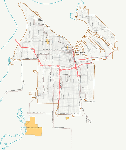
Figure 5: Full extent of labeled current streets with labeled 1891 narrow gauge railroads and landmarks
Finishing Line
To complete the analysis, the digitized features from 1891 were symbolized and labeled accordingly along with the current streets of Tacoma, set at a reference scale of 1:50,000.

Figure 6: 1:24,000 extent where all streets, railroads, and landmark labels can be seen
Created by Anna McDermott, 27 May 2017, apsmcd@uw.edu,
ArcMap 10.4.1
Projection: NAD 1983 HARN State Plane Washington South FIPS 4601 Feet
Data Source: Lab 10 Data